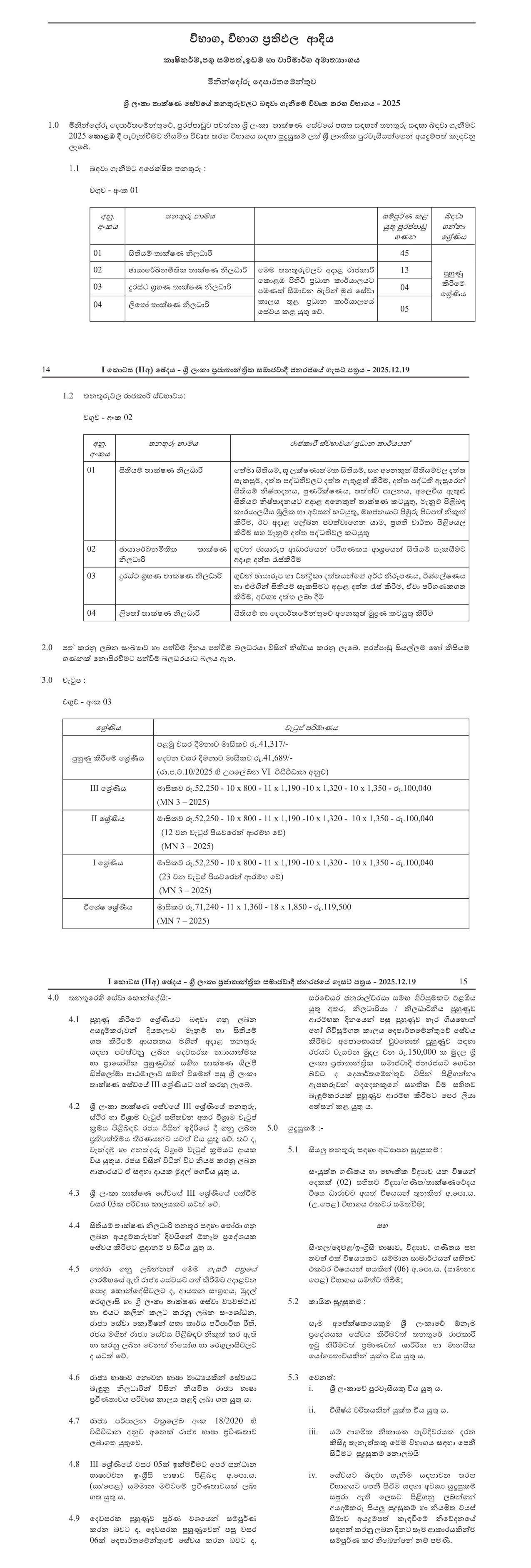
Ministry of Agriculture, Livestock, Land & Irrigation
ñkskafodare fomd¾;fïka;=j
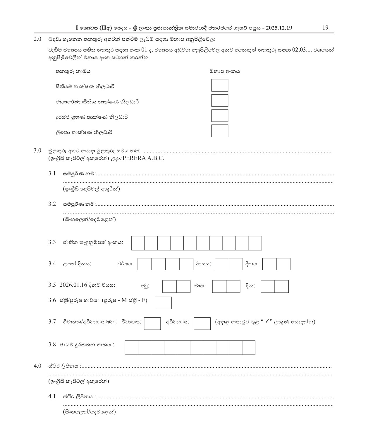
- is;shï ;dlaIK ks,OdÍ
- Pqdhdf¾Lkñ;sl ;dlaIK ks,OdÍ
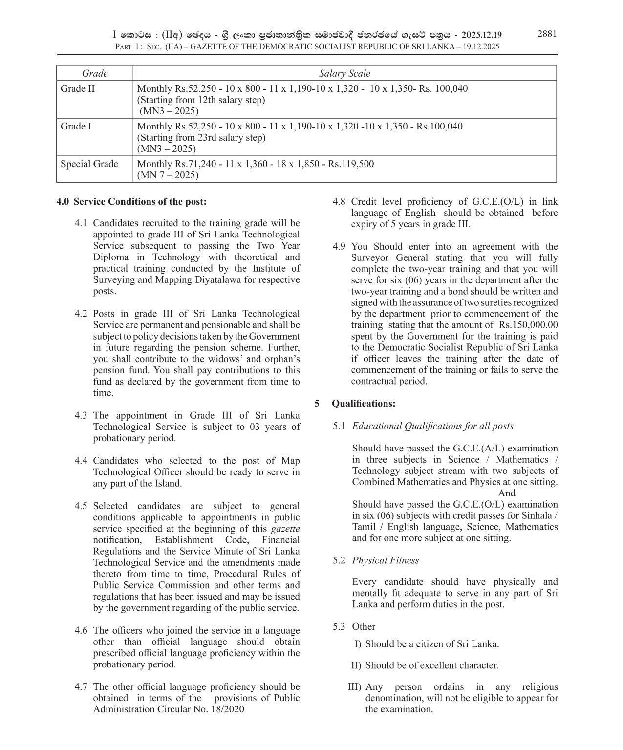
- ÿria: .%yK ;dlaIK ks,OdÍ
- ,sf;da ;dlaIK ks,OdÍ
- Map Technological Officer
- Photogrammetric Technician
- Remote Sensing Technician
- Litho Technician
Job Description
Come join the Ministry of Agriculture, Livestock, Land & Irrigation and be part of a dynamic team dedicated to promoting sustainable land use and agriculture practices. We are currently seeking highly skilled individuals to fill various vacancies within our organization. As a Map Technological Officer, you will utilize your expertise in GIS mapping to support land use planning and natural resource management. The Photogrammetric Technician will play a vital role in producing accurate maps and models using aerial imagery. For those with a passion for analyzing satellite imagery, the Remote Sensing Technician position offers an exciting opportunity to contribute to our land and water resource management efforts. We are also looking for a Litho Technician to assist in the production of topographic maps and aerial photographs. If you have a background in geography, cartography, or geomatics and are looking to make a difference in the field of agriculture and land management, then we want to hear from you. Join us and be part of a team that is shaping the future of sustainable land use and agriculture practices.


Similar Jobs
-
Department of Wildlife Conservation
jkÔú ixrlaIK fomd¾;fïka;=j
Published Date: 12/10/2025Wildlife Conservation Rangers (Open)
jki;aj wvú wdrlaIl ^újD;&
-
Department of Wildlife Conservation
jkÔú ixrlaIK fomd¾;fïka;=j
Published Date: 12/10/2025Wildlife Guard (Open)
jki;a;aj kshdul ^újD;&
-
Condominium Management Authority
iydêm;H l,ukdlrK wêldßh
Published Date: 12/17/2025Senior Engineering Assistant , Secretary , Accounts Officer
fcHYaG bxðfkare iyldr " f,alï " .sKqï ks,Odß
-
Condominium Management Authority
iydêm;H l,ukdlrK wêldßh
Published Date: 12/17/2025Assistant General Manager (Customer Care/HR/Administration) , Customer Care Officer
iyldr idudkHdêldß ^mdßfNda.sl fiajd$udkj iïm;a$mßmd,k& " mdßfNda.sl fiajd ks,Odß
-
Condominium Management Authority
iydêm;H l,ukdlrK wêldßh
Published Date: 12/17/2025Deputy General Manager (Finance/Legal) , Assistant General Manager (Operations/Maintenance)
ksfhdacH idudkHdêldß ^uqo,a$kS;s& " iyldr idudkHdêldß ^fufyhqï$kv;a;=&
-
Homeopathic Medical Council
fydañfhdam;s ffjoH iNdj
Published Date: 12/18/2025Management Assistant , Office Assistant
l,ukdlrK iyldr " ld¾hd, iydhl